
John Stow’s ‘A Survey of London’ is the first history of the capital where the city is the star, rather than the people who lived or ruled there. That’s not to say people don’t feature – intriguingly, “there are all kinds of people mentioned in it that aren’t mentioned anywhere else” in the historic record – but it’s the streets of the wards of the City of London that are the heart of the book.
That’s what Janelle Jenstad told me when we chatted over Zoom recently. Jenstad is a Professor in the Department of English at University of Victoria, Canada, and the Founder and Director of the Map of Early Modern London. The digital project (among many other fascinating things) uses the ‘Survey’ as a key source to annotate places on the mid-16th-Century ‘Agas’ map, as part of an effort to bring William Shakespeare’s London to life.
“I think Stow is a visionary in his conception of how to tell history,” Jenstad says. “He’s the first person who tells the story of London from London’s perspective.
“The ‘Survey’ is a fascinating text because it’s recording London as it’s growing. I sometimes wonder if he’s writing for old Londoners to remind them what London was, or if he’s writing for new Londoners to interpellate them into his idea of London.”
Who was John Stow?
Born in London in 1524 or 1525 (“depending on which calendar one uses”), John Stow was the son of a candlemaker based in Aldgate, in the east of the city. He was a member of the Merchant Taylors’ Company, but his main interests were literature and antiquarian history.
“He’s a collector of books and manuscripts and seems to make his living primarily from editing and writing,” Jenstad says. “He edited Chaucer and other authors’ works, abridged other chroniclers, wrote about England, wrote about Queen Elizabeth I, and eventually wrote about London.”
Stow’s ‘Survey’ was published across four editions: 1598, 1603, 1618, and 1633. The first two were penned by Stow himself, and the second two overseen and expanded upon after his death in 1605 by his friend and fellow antiquarian, Anthony Munday. (It was later picked up by John Strype in 1720 and further iterations published under his name.) During this time, London’s population changed from around 200,000 in 1600 and around 400,000 in 1650.
The ‘Survey’ changed across time, too: from quarto (around 30cm tall) to folio size (around 40cm tall), from 485 to 990 pages, and from a wide target audience to a more elite one.
“The first edition was quarto size, printed in black letter type, which is considered to be the more accessible font of the period. It’s a sign that Stow was imagining a common readership,” Jenstad says. By the fourth edition, it’s being printed in folio size and is “likely out of the price range of most people; it would be bought by people with money. It goes from being a book of the people in 1598 to being a book of the Corporation of London by 1633.”
Indeed, the 1633 edition features the coats of arms of the City of London and all its livery companies, and Jenstad says “we have records of livery companies paying for copies”.
What actually is the ‘Survey’?
The ‘Survey’ is organised into three sections. The first covers the walls, gates, and bridges of the city, its schools, and its customs, sports, and pastimes. The third section looks at the governance of the city. The second section is the important one, the street-by-street tour of the 25 wards of London, plus the Borough of Southwark and Bridge Ward Without. In the 1633 edition, it expanded to cover around 4miles outside the city walls (“The person who did that work – we’re not entirely sure who it is – seems to have handed in his notes really late, so they’re published at the back of the book.”).
In each ward, Stow first describes the perimeter, then documents the length of each east-to-west street, before covering the streets that branch off it to the north, and then the streets that branch off it to the south. He starts from the wards in the east of the city, working his way across to the west.
But despite the meticulousness of the mapping, Jenstad cautions that “the content of the ‘Survey’ tends to be biased towards a fairly sanitised version of London”. For example, there’s no mention of crime or prostitution, of entertainment such as bear baiting, of overcrowding, dirt, and sewage.
What is the legacy of Stow’s ‘Survey’?
Jenstad says: “It doesn’t tell us a complete history of London, but then no history ever does. Histories are stories told from a particular perspective. But it’s a wonderful source, as long as you keep in mind what Stow didn’t write about.”
Indeed, she considers Stow’s work among her most valuable resources; so much so that she published her own transcription of the 1633 edition on the Map of Early Modern London site, and is working on a project to “put the four editions side by side and allow you to see how they evolve”.
“The 1633 text in particular should be more widely used than it is by historians. It has so much more information [than the earlier editions] and covers a really crucial period of London’s history – the whole shift to the Stuart era and the lead up to the Civil War. And the fact it says on the title page that it’s ‘now completely finished’.”
Jenstad believes historians tend to default to the 1603 edition, the last one published during Stow’s lifetime, but “I’d really like the 1633 to be the canonical text”.
It’s a fitting hope: that a man who put place before people in the works of his lifetime should not be privileged as a person over the comprehensiveness of those works released after his death.
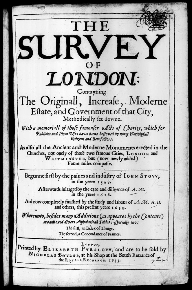
The 1633 edition, now called ‘The Survey of London’, was printed by Elizabeth Purslow(e), widow of George, who died in 1632. Jenstad says: “This is, if not the first, one of the earliest books that has her name on it. It’s so beautifully printed that I figure she’d been involved in the printing all along.” Image courtesy of the Internet Archive.

When I spoke with Jenstad, she told me the ‘Survey’ wasn’t intended as a literal guidebook. Despite the portable size of the first three editions, she said: “I’m not actually sure that Stow imagined anybody walking around with it in their hand”. She described it instead as a guide to “travel in your mind”.
But what if we did try to use it on the ground?
The privilege of living in London is the ability to see in real life how the city has both changed from, and stayed the same as, the historic descriptions of it. And so, I set out to do just that.
I chose Stow’s local area, Aldgate Ward, and using the text of the 1633 edition, focused on following his description of its bounds – the east-to-west main roads, the north and south streets that run off them, and some of their key landmarks.
Of the 13 streets explicitly mentioned in this portion of the ‘Survey’, all but one of them can be clearly found today, albeit with sometimes changed or slight variations of the names (eg: Stow’s Sugarloafe Alley – off today’s Leadenhall Street, this section of which was formerly known as Aldgate Street – is now Fenchurch Buildings; Woodroofe Lane, leading to Tower Hill, is now Cooper’s Row; Sydon Lane is now Seething Lane; Mart Lane is now Mark Lane). The outlier is Culver Alley, off Fenchurch Street, which from a comparison of 16th and 17th-Century and modern maps, may have been somewhere near to or between today’s Fen Court and Hogarth Court, or may in fact be today’s Cullum Street. A water pump (with wolf head spout), which replaced a former well where Aldgate “divided into twaine”, still stands around the same spot.
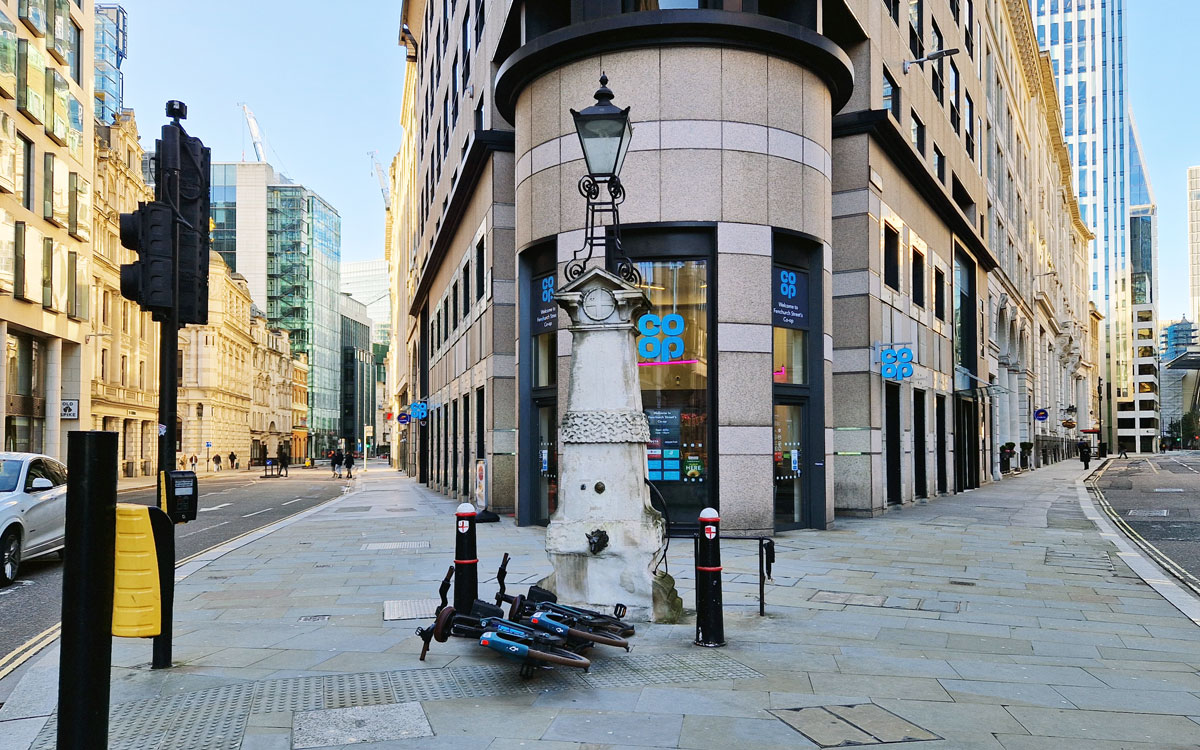
Stow wrote: “The principall street of this Ward beginneth at Ealdgate, stretching West to sometime a faire Well, where now a Pumpe is placed. From thence (the way being divided into twaine)…”
The halls of the two livery companies Stow names – Bricklayers and Ironmongers – are gone, now in their place a corporate office building and Rolex store, respectively. And of the five places of worship mentioned, two survive, including St Andrew Undershaft, where Stow is commemorated with a statue showing him at work on his writings.
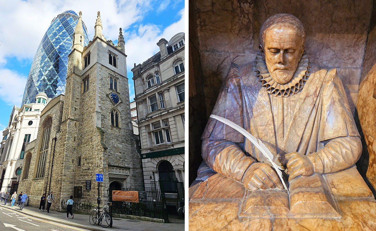
St Andrew Undershaft, left; and the Jon Stow memorial statue inside, right.
